$15 billion floodwalls are sinking — satellite maps reveal New Orleans’ slow-motion collapse.
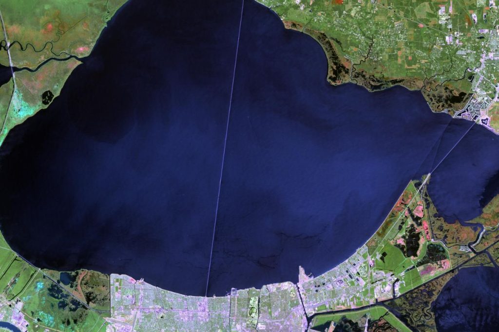
From above, New Orleans looks as still as a postcard. But beneath the streets, wetlands, and even the gleaming post-Katrina flood defenses, the ground is quietly dropping — in some places, by nearly two inches a year. A Tulane University study using two decades of satellite radar data has uncovered a problem that could erode the very walls meant to save the city.
You can also read:
- Germany is burying a battery the size of a skyscraper—inside a salt cave !
- An old report resurfaces after 20 years—and could make Mexico a global hydrogen powerhouse
A city losing height inch by inch
Between 2002 and 2020, researchers mapped changes in ground elevation across Greater New Orleans using InSAR — a satellite radar technique sensitive enough to detect shifts of just a few millimeters. The findings, published in Science Advances, show an uneven but unmistakable trend: parts of the city, surrounding wetlands, and even billion-dollar floodwalls are sinking faster than sea levels are rising.
Lead author Simone Fiaschi warns that even slight drops in elevation can tip the balance in a place already flirting with sea level: “In New Orleans, inches matter. A minor change in height can turn a manageable flood into a disaster.”
Why the ground is giving way
Subsidence here isn’t caused by a single force but a tangle of natural and human pressures:
- Natural soil compaction as sediment layers settle over time
- Groundwater extraction lowering underground water tables
- Industrial development stressing the land
- Wetland drainage for urban growth, removing nature’s spongy support
The result is a patchwork of land movement, where some neighborhoods sink rapidly while others remain stable — or even rise slightly when industrial pumping stops.
The Sky Is Burning the Forest: 1 Billion Tonnes of CO₂ Released, and We Barely Noticed
The unsettling truth about the floodwalls
Perhaps the most alarming discovery is that parts of the Hurricane and Storm Damage Risk Reduction System (HSDRRS) — the network of levees and floodwalls built after Katrina at a cost of roughly $15 billion — are themselves sinking.
In certain segments, concrete floodwalls are losing elevation faster than the ocean is gaining it, meaning their protective “freeboard” is shrinking year by year. Co-author Prof. Mead Allison is blunt: “These results are a wake-up call. We must maintain and adapt our defenses, or the protection we think we have will quietly slip beneath us.”
Wetlands on the edge of disappearing
East of the city, the coastal marshes — vital buffers against storm surges — are also losing ground. In some hotspots, the drop in elevation is so fast that marshland could turn to open water within a decade. That’s a double loss: for wildlife and for the human communities relying on those wetlands to blunt hurricanes.
A narrowing margin of safety
New Orleans’ survival depends on a finely tuned system of levees, pumps, and canals. Rising seas already push that system to its limits. Add subsidence, and the safety margin shrinks dangerously.
Without continuous monitoring — combining satellites like those used in this study with ground surveys — city planners won’t know which sections of levee to reinforce or when. The risk isn’t hypothetical; it’s playing out in real time, in inches.
Climate change: We missed the 1.5°C target — And we’re still stepping on the gas
A lesson for coasts worldwide
While this study focuses on New Orleans, its implications stretch far beyond Louisiana. Coastal cities from Jakarta to Miami face the same double bind of sinking land and rising seas. Tulane’s work shows how satellite radar can pinpoint trouble spots before they fail — if leaders are willing to act on the warnings.
In the words of Fiaschi: “Our maps show where the ground is moving, but in a city like this, knowing isn’t enough. It’s what you do next that decides whether you stay dry.”
Source:
“Vertical land motion in Greater New Orleans: Insights into underlying drivers and impact to flood protection infrastructure” by Simone Fiaschi, Mead A. Allison and Cathleen E. Jones, 27 June 2025, Science Advances.
DOI: 10.1126/sciadv.adt5046